 Teach English in Asia
  Cruise Ship Jobs
 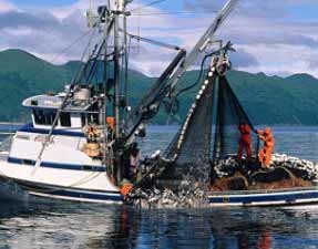 Alaska Fishing Industry Jobs
  Sharing Economy / Gig Economy
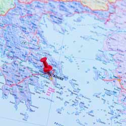
 Cartography Jobs
When was the last time you used a map? Was it on a road trip, hiking through the mountains, exploring an unknown area, searching for buried treasure, avoiding traffic with your GPS, or locating a foreign city? Maps are used all over the world for all sorts of things. Every one is the creation of a skilled cartographer.
Cartographers, or mapmakers, create, design, and produce maps. Society depends on them. Maps are key for road construction, weather forecasting, fishing, skiing, land planning, real estate, search and rescue, forest management, mineral prospecting, navigation, aviation, and plenty of other fields.
Maps show us our surroundings in a way that we can understand and use.
The skill and art of mapmaking has been around since the beginning of time. Originally maps were based on what people saw and remembered, or imagined. With constantly evolving technology, cartographers are changing the field. Cartographers use software like CAD or GIS (See: GIS Specialist Jobs) to create maps and store them in databases. Technology makes it easy to update and share information. What would the world be without Google Maps or GPS?
Every map has a purpose and it’s up to the cartographer to define that purpose. A cartographer must create a map that easy to read and understand. They must determine what is relevant and what is important. This is often dictated by what they are mapping – stars, roads, topography, the world, the ocean, cities, or weather.
Maps come in different shapes, sizes, and mediums. Maps can be paper, 3D, or virtual. They can be to scale like topographic maps with contour lines or topological like a subway system map. The style of map depends on what it represents. A 3D map may be good to represent the plans for a golf course community, a paper map is ideal for a road atlas, and a virtual map is ideal for a backpacker’s GPS.
Cartographers determine what to include on every map. Most maps have a compass, scale, legend, publication date, color definitions, and other important things. But it is up to the mapmaker to decide what mountain peaks, back roads, rest areas, or trails to include. No map can include everything, but some mapmakers think it is funny to include phantom mountain peaks or fictitious names just to see if you are paying attention.
The most important aspect of any map is its accuracy. An inaccurate map is absolutely worthless. Cartographers use aerial photos, satellite images, surveying equipment, laser range finders, GPS, specialized cameras, drafting instruments, and scanners to help them model the Earth. Most of the time they create their maps from an office.
Only occasionally do they get to visit and explore the places they map.
Cartographers usually go to school for geological information science, engineering, or physical sciences. They need an education in science, cartography, and design software. Cartographers need to develop a professional portfolio of completed maps. A polished portfolio will help them land a job in the private mapping sector or work with the federal government.
Mapmaking is a nice mix of design and science. It can be challenging to create the perfect map, but the ultimate goal of every map is that it is useful and easy to read and understand. This ancient profession is one that continues to let people explore the globe. It is a profession that is always advancing. As long as roads are built, political boundaries, and terrain changes cartographers will have job security.
Quick Facts About Cartography Positions
Job Title: Cartographer, Mapmaker, Mapping Scientist
Office: With a computer or in the field
Description: Create, design, and produce accurate maps
Certifications/Education: University degree in engineering or physical science
Necessary Skills: Accuracy, Knowledge of Mapping Technology – GIS, CAD
Potential Employers: Governments, Mapping Companies
Helpful Cartographer Employment Links:
Search Cartographer Jobs on JobMonkey
American Congress on Surveying and Mapping
International Map Industry Association
Cartography and Geographic Information Society
North American Cartographic Information Society
International Cartographic Association
United States Geological Survey